Management & Delineation Project
General Data
Title | Management-Delineation of Rafina's River |
Type of project | Flood protection measures and water flow management |
Project Owner | Hellenic Ministry of Infrastructure, Transport & Networks Directorate of Flood Protection & Land Improvement Projects |
Licensing Authority | Hellenic Ministry of Environment and Energy, Directorate of Environmental Licensing |
Operational plan | Transport infrastructure, Environment & Sustainable Development |
Axis of Priority | Implementation of Climate Change Adaptation Strategies, of Risk Prevention and Management |
Output |
|
Budget | 101,5 million € |
Funding | European Investment Bank - 36,6 million € NSRF / Cohesion Fund - 30,3 million € National Resources - 17,5 million € Council of Europe Development Bank - 17,1 million € |
The information given here comes from publicly available documents, the project’s Final Study and the Environmental Impact Assesment (EIA). The relevant files can be downloaded from the links at the bottom of the page.
The table above gives the general information regarding the project, while the drawing below shows the general layout of the planned works. More detailed visualization can be found on our digital interactive map.

Management & Delineation Project
River management cross-sections
Three different types of cross section will be used which are briefly described below. The type and dimensions of the cross-section at each point of the river are shown in detail on the digital map (see e.g. the side image).
It is noted that out of the 17 km of riverbed included in the project, only 500 m will remain in its natural state.

They are mainly applied near the town of Rafina and in the area of the confluence with Valanaris. Specifically, in Rafina, from the estuary to the height of Dimokratias Street (EKO) and in a length of 1.5 km, the riverbed and banks of the Great River will be covered almost entirely by heavy reinforced concrete.
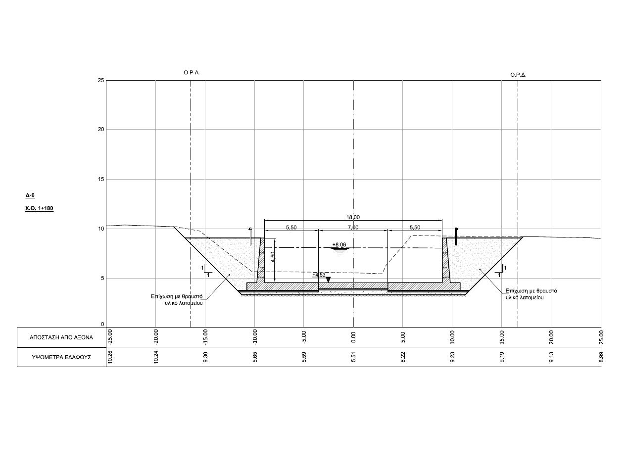
The cross-sections will be rectangular with the side walls supported either by a footing or by 1 m diameter and 10 m depth concrete piles. The bottom will have a 0.6 m thick concrete slab.
Total length | 2.367 m |
Width | 16 to 31 m |
Depth | 3,0 to 4,5 m |


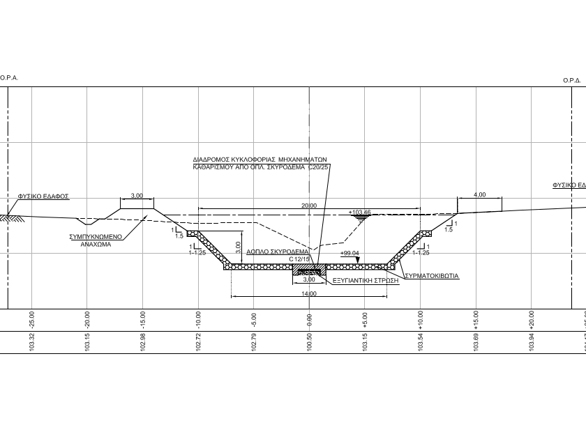
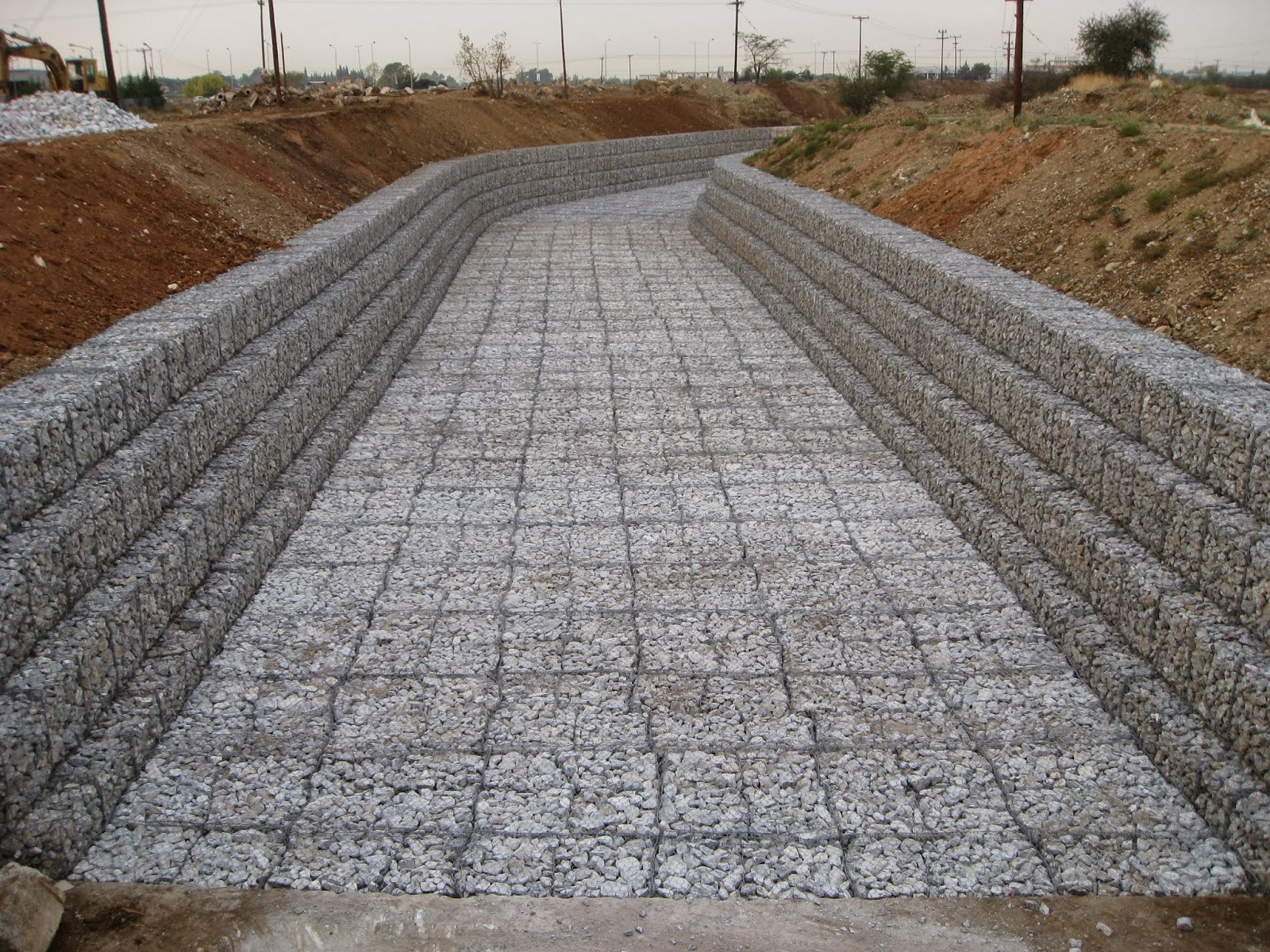
They are applied to the larger part of the project. Gabions of 0.5 m thickness will be used. The cross-sections will be mainly trapezoidal, where on the slopes the gabions are positioned in steps or sideways. The bottom will also be lined with gabions of the same thickness and in most places there will be a 3.0m wide concrete machinery walkway in the centre.
Total length | 10.345 m |
Width | 11 to 22 m |
Depth | 3,0 to 4,5 m |


They are mainly applied in the plain of Spata, from the position of KEL Mesogeion and upstream until shortly after the Petreza bridge. They consist of a central section with gabions with earthen levees on either side, i.e. embankments with a flattened top 3 – 4 m wide. The earthen slopes will be covered with geogrids while at a distance of 25 – 50 m gabions will be placed across the banks for protection.
Total length | 3.780 m |
Width of central part | 20 to 25 m |
Depth | 3,0 to 3,5 m |

Management & Delineation Project
Hydrological data
The design of the project was based on the hydrological study of 2016 , considering a flood with a return period of 50 years (T50) and a rainfall of 12 hours.
The water supply predicted at the mouth of the Great River is shown in the adjacent Table 1. Starting from the pre-2016 existing situation (supply of 485 cumecs), in the coming years a significant increase is predicted, mainly due to construction in the area, with the supply reaching 520 cumecs.
Table 1
Water supply at the mouth of Rafina’s Great River for a 50-year flood
In cumecs = cubic meters per second
Existing situation (2016) | 485 |
Future situation - no works | 520 |
Future situation - with works | 540 |
Future situation - with works + dam | 460 |
The implementation of the planned management project using hard, impermeable materials will further increase the flow at the estuary, which will eventually reach 540 from 520 cumecs. This means that, according to the study, the works on river bed will induce an increase in the amount of water that reaches the estuary and, consequently, an aggravation of the flood risk. According to the engineers, the only way to reduce this significantly increased water supply is to build a dam: “Completion of flood protection will be achieved by the construction of the retention dam in the plain of Spata…” (pp. 2-9, CH. 2, E.I.A.)
Indeed, taking into account the dam, the supply at the estuary becomes 460 cumecs, i.e. a reduction is achieved compared to the existing situation in 2016. But here comes the great paradox of the project:
The dam will not be built in the so-called Phase I, but management works will be constructed as if the dam were in place, i.e., for a water flow of 460 cumecs!
This means that in a possible 50-year flood we will have 80 cumecs (=540-460) above the nominal capacity of the project with a high probability of significant overflow. It is also noteworthy that the dam: a) is left for the vague “Phase II”, with a 10-year time horizon, b) is not included in the E.I.A. and c) the study leaves open the possibility that the dam will not be built at all.